Center for Uncertainty Studies Blog
Digital Academy 2023: Dealing with Doubts: Site Georeferencing in Archaeology and in the Geosciences
From September 25 to 28, 2023, the Digital History Working Group at Bielefeld University welcomed participants to the Digital Academy, themed "From Uncertainty to Action: Advancing Research with Digital Data." This event delved into the complexities of data-based research, exploring strategies to navigate uncertainties within the Digital Humanities. In a series of blog posts, four attendees of the workshop program share insights into their work on data collections and analysis and reflect on the knowledge gained from the interdisciplinary discussions at the Digital Academy. Learn more about the event visiting the Digital Academy Website.
Dealing with doubts: Site Georeferencing in Archaeology and in the Geosciences
by Florian Thiery
Introduction
Archaeological research must handle doubts – in the context of NFDI4Objects1 often named using the umbrella terms “fuzziness and wobbliness” ((Thiery et al. 2021)) – such as vagueness, uncertainty, and ambiguities in data modelling. Here, “vagueness” is a measure of the precision of a statement; a vague statement is therefore only true to a certain degree. In the case of “uncertainty,” it is completely unknown whether the statement made is true at all (Unold, Thiery, and Mees 2019; Thiery and Mees 2023). This occurs especially in georeferencing. However, creating reproducible and comprehensible data for reuse while guaranteeing data quality in archaeological data involves disclosing doubts and ambiguities (Thiery and Mees 2023). This is also important for data FAIRification, (process to make data Findable, Accessible, Interoperable, Reusable)2 addressed in the NFDI. Especially vagueness and uncertainty must be modelled to work with geodata. However, for linking data and FAIRification graph-based modelling as Linked Open Data (LOD) proposed by (Berners-Lee 2006), cf. (Schmidt, Thiery, and Trognitz 2022)) is the technique of choice. Due to the huge variety of research domains, an interdisciplinary, commonly understandable framework for modelling of uncertainties and vagueness in research data is extremely challenging. We will present three data-driven interdisciplinary use cases of dealing with and modelling vague and uncertain geo-references (findspots) based on literature as LOD from the archaeological and geosciences domain.
Modelling Approaches
- describe where the geoinformation comes from
- describe the method of how the coordinate was created
- describe the uncertainty issue(s)
- use references into the Semantic Web
I. Wikidata
The Wikidata example will be practically explained using the examples of Irish Ogham stones. Ogham stones are monoliths with the early medieval primitive Irish Ogham script, mostly erected on the island of Ireland and in the western part of Britain between the 4th and 9th centuries. Most stones are no longer at the original site, which is important for cartographic recording and makes it more difficult to determine their original function (Macalister 1945).
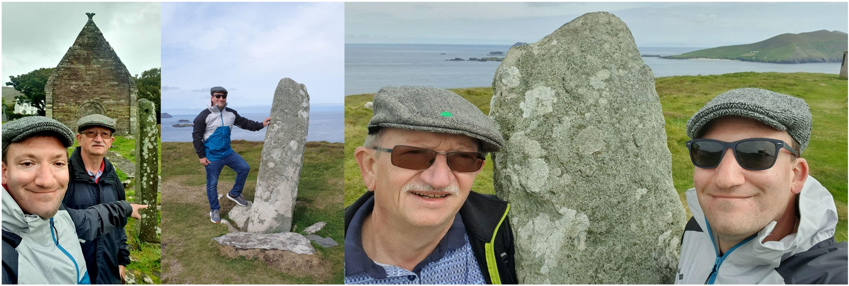 Figure 1: Florian Thiery and his dad in front of two Ogham stones (left: CIIC 187, the Kilmalkedar Ogham Stone, OSM node 91104026483; middle/right: CIIC 178, the Coumeenoole Ogham Stone at Dunmore Head, the most western point of Ireland, OSM node 51454136404 on the Dingle Peninsula on an expedition trip. Florian Thiery & Peter Thiery CC BY 4.0.
- qualifier: P1180 sourcing circumstances
- qualifier: P248 stated in
- qualifier: P276 location
- qualifier: P459 determination method
- qualifier: P2868 subject has role
- reference: P11693 OpenStreetMap node ID
Ogham Stones, which are only available in literature and/or online databases such as “Ogham in 3D” or CISP (Figure 3):
- qualifier: P248 stated in
- qualifier: P3831 object has role
- qualifier: P459 determination method
- qualifier: P2868 subject has role
- reference: P854 reference URL
 Figure 2: Ex-situ Ogham Stone with on-site survey. Modelling in Wikidata. Florian Thiery CC BY 4.0.

Figure 3: Ogham Stone: only Literature as Source. Modelling in Wikidata. Florian Thiery CC BY 4.0.
II. Fuzzy Spatial Locations Ontology (FSLO)
The Fuzzy Spatial Locations Ontology is based on famous and well-known ontology in the field such as PROV-O (Provenance Ontology)5, SKOS (Simple Knowledge Organization System)6 and GeoSPARQL (Standard by the Open Geospatial Concortium (OGC)7. It follows the PROV-O concept of Entity, Activity and Agent (Figure 4). In the case of this ontology, Sites (entity) have a Geometry and were created using a Method (activity) by a Person (agent), c.f. Figure 5. The site and geometry include two properties to describe certainty: fsl:certaintyDesc and fsl:certaintyLevel. The resulting Linked Open Data as RDF can be transformed into human-readable HTML files using the SPARQL Unicorn Ontology Documentation research tool (Homburg and Thiery 2024).
 Figure 4: Schematic view of the Fuzzy Spatial Locations Ontology based on the PROV-O ontology. Florian Thiery CC BY 4.0.
 Figure 5: Schematic view of the Fuzzy Spatial Locations Ontology and its relations, based on the PROV-O ontology. Florian Thiery CC BY 4.0.
III. Wikibase
- has certainty level
- certainty description
- method used
- acting person
- has source
- has source subtype
- method description
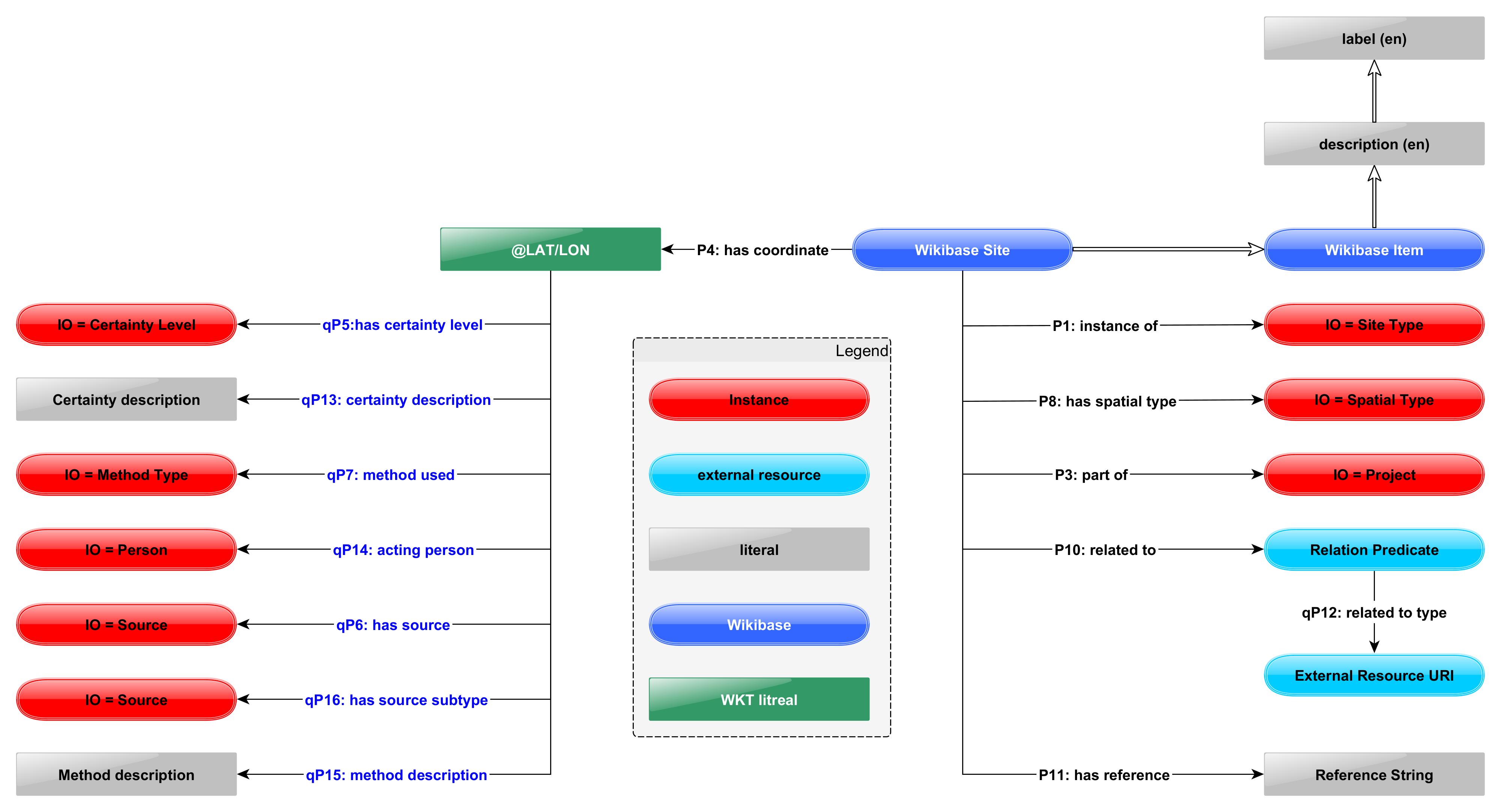
Figure 6: Wikibase Data Model of a site. Florian Thiery CC BY 4.0.
Use Cases
I. Irish Ogham Stones (Wikidata)
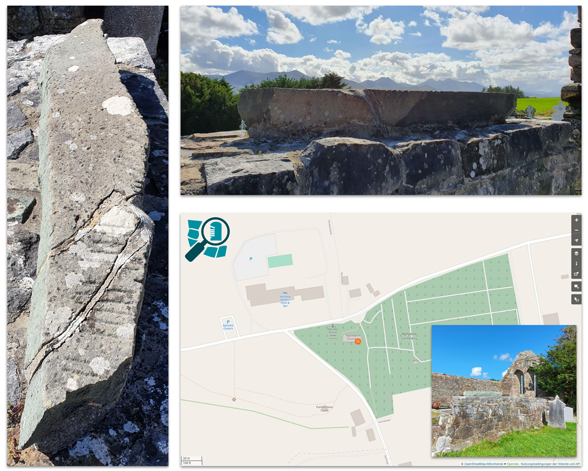
Figure 7: Ogham Stone CIIC 242 (SMR No. KE066-016005-) at the Aghadoe Church Ruin (SMR No. KE066-016001-) near 52,0767683, -9,5543233. Images by Florian Thiery, right-bottom: Map by © Open Street Map Contributors under Open Data Commons Open Database License (ODbL) by the OpenStreetMap Foundation (OSMF), via https://www.openstreetmap.org/node/10040757680 by fthierygeo.Florian Thiery, CC BY 4.0, via Wikimedia Commons.
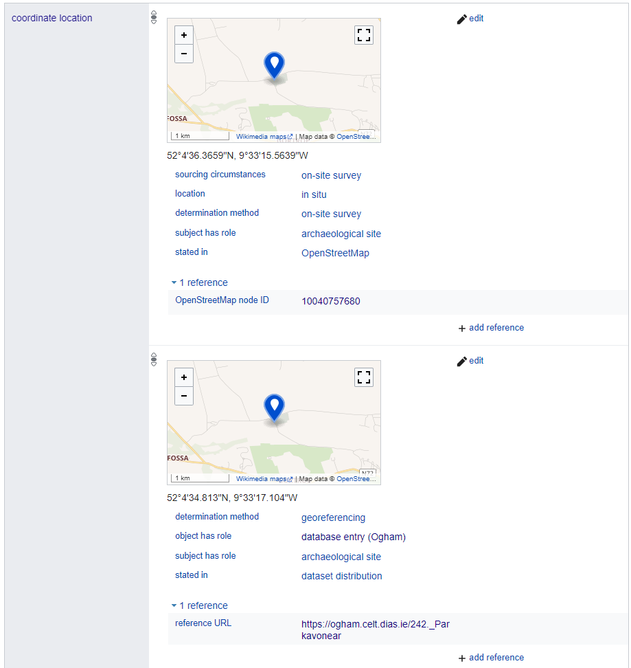
Figure 8: Coordinate locations (P625) of Ogham Stone CIIC 242 in Wikidata (Q106680977). Public Domain.
II. Campanian Ignimbrite (CI) ash airfall (LOD / FSLO)
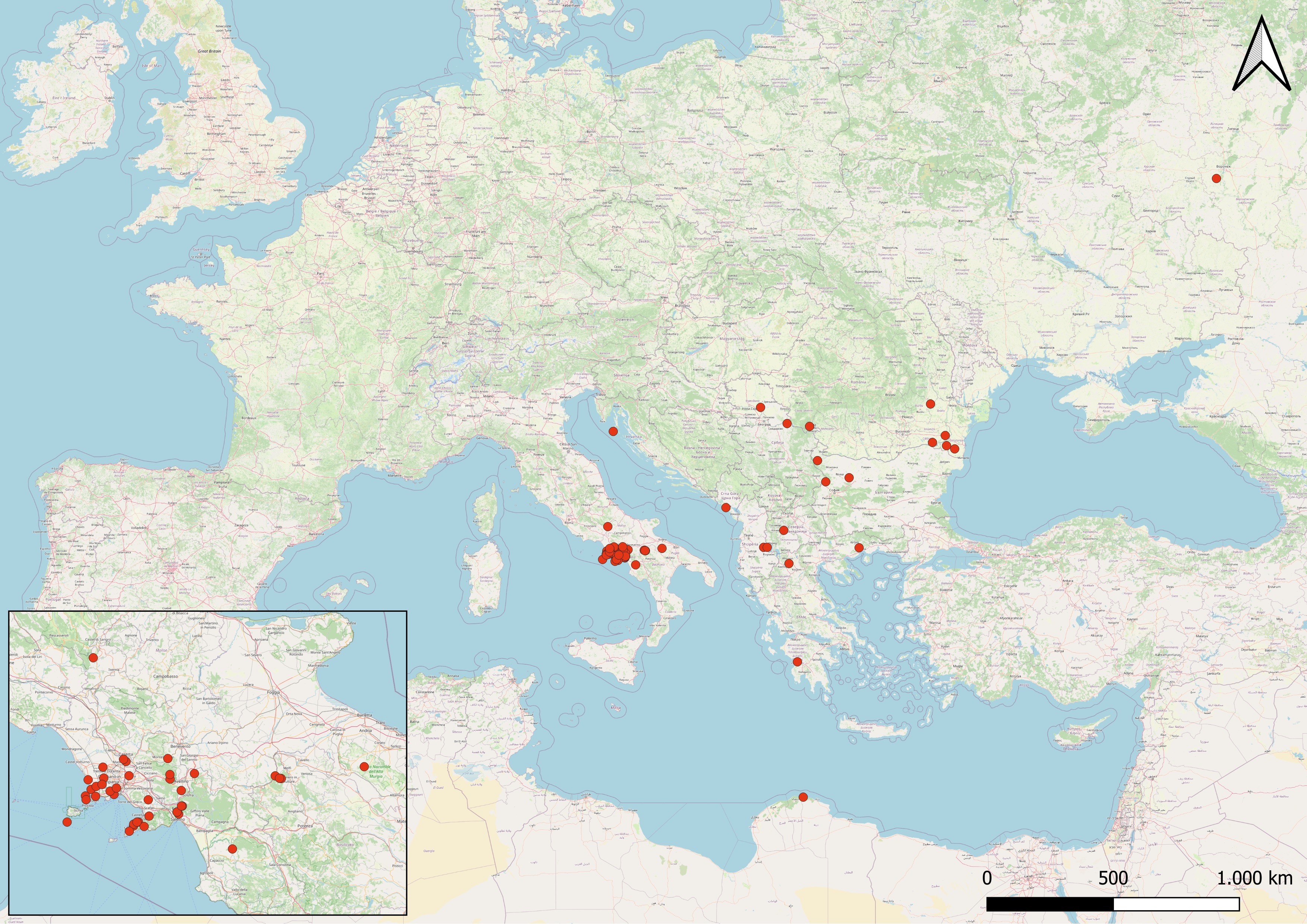
One Findspot is Urluia in Romania. Spatial information about this findspot is mentioned in some papers, such as Fitzsimmons and Hambach (2014, 76), “[...] the site of Urluia Quarry on the Dobrogea loess plateau [...], some 15 km south of the Danube River.” Or Pötter et al. (2021, 5), “The Urluia [...] is located in an abandoned limestone quarry on the limestone plateau of the Dobrogea [...]”. Investigations on OSM showed that this limestone quarry is described using way/84975654, resulting in a coordinate POINT(27.9021 44.0947). This can be modelled using the Fuzzy Spatial Locations Ontology as Linked Open Data in cisite_52.
III. Silver Coinage of Croton (Wikibase)
Research on the silver coinage of Croton, an Achaean colony in southern Italy from the 6th - 3rd century BC, e.g. examines the material under numismatic, historical, and archaeological methods to reconstruct the monetary history of the ancient city. The geo-locations of the finds are almost all not exactly georeferenced (e.g., by use of the documentation of excavation reports). The determined locations are derived from literature and have varying degrees of precision regarding the location of the find spot. An example of the uncertainy information of a find at Esaro River in 1967 shows the challenges:
"There is only the information that the hoard was found on the river Esaro, without specifying exactly where on the river course. In the literature, there is information that it was found "in Crotone", by which the city rather than the province is meant; otherwise, it would have been formulated differently. The urban area of the river course ends shortly after the "Strada Statale 106 Jonica". The most likely location for the find is along the course of the river between the section just before the motorway and the mouth of the river in the sea. Since the find was made in 1967, the river's course at that time probably corresponds fairly closely to the course of the river today. However, both the latter and the presumed find section are conjectures."
This information is modelled using the Wikibase approach as entity Q67 and can be shown in a wikibase.cloud instance for fuzzy-sl at https://fuzzy-sl.wikibase.cloud/entity/Q67.
Digital Academy
Biographical note
Footnotes
1. https://www.nfdi4objects.net.
2. Cf. https://www.go-fair.org/fair-principles/.
3. https://www.openstreetmap.org/node/9110402648.
4. https://www.openstreetmap.org/node/5145413640.
5. http://www.w3.org/TR/prov-o/.
6. https://www.w3.org/TR/skos-primer/.
7. https://www.ogc.org/standard/geosparql/.
8. https://www.openstreetmap.org/node/10040757680.
9. https://ogham.celt.dias.ie/242._Parkavonear
References
Barberi, F., Innocenti, F., Lirer, L., Munno, R., Pescatore, T., and Santacroce, R. 1978. ‘The Campanian Ignimbrite: A Major Prehistoric Eruption in the Neapolitan Area (Italy)’. Bulletin of Volcanology 41.
Berners-Lee, Tim. 2006. ‘Linked Data - Design Issues’. 27 July 2006. https://www.w3.org/DesignIssues/LinkedData.html. Accessed March 15, 2024.
De Vivo, B., G. Rolandi, P. B. Gans, A. Calvert, W. A. Bohrson, F. J. Spera, and H. E. Belkin. 2001. ‘New Constraints on the Pyroclastic Eruptive History of the Campanian Volcanic Plain (Italy)’. Mineralogy and Petrology 73 (1–3): 47–65. https://doi.org/10.1007/s007100170010.
Fitzsimmons, Kathryn E., and Ulrich Hambach. 2014. ‘Loess Accumulation during the Last Glacial Maximum: Evidence from Urluia, Southeastern Romania’. Quaternary International 334–335 (June): 74–85. https://doi.org/10.1016/j.quaint.2013.08.005.
Homburg, Timo, and Florian Thiery. 2024. ‘Sparqlunicorn/sparqlunicornGoesGIS-Ontdoc: Version 0.17’. Squirrel Papers 6 (2): #2. https://doi.org/10.5281/zenodo.8190763.
Macalister, Robert Alexander Stewart. Corpus Inscriptionum Insularum Celticarum. Vol. I. Dublin: Stationery Office, 1945.
Morin, Eugene, and Marie-Cécile Soulier. ‘The Paleolithic Faunal Remains from Crvena Stijena’. In Crvena Stijena in Cultural and Ecological Context. Multidisciplinary Archaeological Research in Montenegro, edited by Robert Whallon, 266–294. Podgorica: Montenegrin Academy of Sciences and Arts, 2017.
Morley, Mike W., and Jamie C. Woodward. 2011. ‘The Campanian Ignimbrite (Y5) Tephra at Crvena Stijena Rockshelter, Montenegro’. Quaternary Research 75 (3): 683–96. https://doi.org/10.1016/j.yqres.2011.02.005.
Pötter, Stephan, Daniel Veres, Yunus Baykal, Janina J. Nett, Philipp Schulte, Ulrich Hambach, and Frank Lehmkuhl. 2021. ‘Disentangling Sedimentary Pathways for the Pleniglacial Lower Danube Loess Based on Geochemical Signatures’. Frontiers in Earth Science 9 (April): 600010. https://doi.org/10.3389/feart.2021.600010.
Schmidt, Sophie C., Florian Thiery, and Martina Trognitz. 2022. ‘Practices of Linked Open Data in Archaeology and Their Realisation in Wikidata’. Digital 2 (3): 333–64. https://doi.org/10.3390/digital2030019.
Thiery, Florian, and Allard Mees. 2023. ‘Taming Ambiguity - Dealing with Doubts in Archaeological Datasets Using LOD’. CAA 2018: Human History and Digital Future, October. https://doi.org/10.15496/PUBLIKATION-87762.
Thiery, Florian, Allard Mees, Karsten Tolle, and David Wigg-Wolf. 2021. ‘TRAIL2.2: Evaluation of Fuzziness and Wobbliness in Numismatics and Ceramology’. NFDI4Objects TRAILS 2021 (October): No. 2.2. https://doi.org/10.5281/zenodo.5654897.
Unold, Martin, Florian Thiery, and Allard Mees. 2019. ‘Academic Meta Tool. Ein Web-Tool Zur Modellierung von Vagheit’. ZfdG - Zeitschrift Für Digitale Geisteswissenschaften Die Modellierung des Zweifels – Schlüsselideen und-konzepte zur graphbasierten Modellierung von Unsicherheiten. (Sonderband 4). https://doi.org/10.17175/SB004_004.